our partners


Get updates on mail
address
270 Angas St,
Adelaide SA 5000
Copyright © 2026 Bicycle SA. All Rights Reserved.
270 Angas St,
Adelaide SA 5000
Copyright © 2026 Bicycle SA. All Rights Reserved.
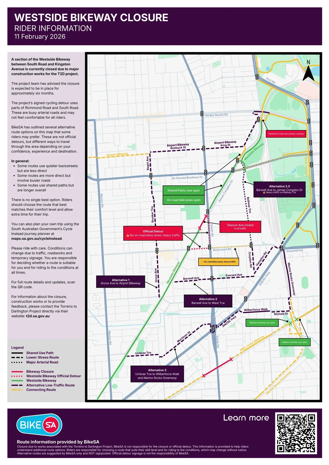
section of the Westside Bikeway between South Road and Kingston Avenue is currently closed due to works associated with the Torrens to Darlington Project. The project team has advised BikeSA that Deacon Avenue in this area is expected to be closed for approximately six months.
The project’s signed cycling detour uses parts of Richmond Road and South Road. These are busy arterial roads and may not feel comfortable for all riders.
We know this section of the Westside Bikeway is an important, lower-stress link for many people riding to work, school and the city. Sudden changes like this can be frustrating and disruptive, especially when the signed detour does not feel comfortable for everyone.
BikeSA has prepared the information below to help riders understand other route options through the area. These are not official detours, but alternatives some riders may prefer depending on confidence, experience and trip purpose.
In general:
There is no single best option. Riders should choose the route that best matches their comfort level and allow extra time for their trip.
Please ride with care. Conditions can change due to traffic, roadworks and temporary signage.

There is no single best alternative. The right option depends on how confident you feel riding in traffic, how direct you need your trip to be and whether you prefer paths or roads.
Distance to Grenfell St/West Tce intersection: 5.1km
This is a less direct but quieter option utilising more local residential streets and collector roads.
The route leaves the Westside Bikeway at Grove Avenue, then follows Brooker Terrace, Bagot Avenue, the Airport Bikeway along Roebuck and King Streets, before reconnecting with the Westside Bikeway closer to the city.
This option avoids the busiest arterial roads but is less direct and requires more navigation.
This option may suit you if you:
What to expect:
Distance to Grenfell St/West Tce intersection: 3.5km
This is a more direct route utilising local residential streets and some busier collector roads.
The route leaves the Westside Bikeway at Barwell Avenue, then takes Everard Avenue, Hampton Road, a short section of Richmond Road (with optional footpath riding), then connecting to the West Terrace path into the city.
This option is more direct but includes higher traffic conditions and requires confidence riding near vehicles.
This option may suit you if you:
What to expect:
Distance to Grenfell St/West Tce intersection: 4.7km
This is a less direct route utilising local residential streets, some busier collector roads, and Railway Terrace, which is part of the busy city Ring Road.
The route leaves the Westside Bikeway at Barwell Avenue, then takes Everard Avenue, Croydon Road, Railway Terrace, then connecting to the Westside Bikeway at James Congdon Drive.
This option is more direct but includes higher traffic conditions and requires more confidence riding near vehicles.
This option may suit you if you:
What to expect:
Distance to Grenfell St/West Tce intersection: 6km
This is a calmer but less direct route utilising local residential streets and dedicated shared use paths, and requires some footpath navigation along ANZAC Highway.
The route leaves the Westside Bikeway at Urrbrae Terrace, then takes Mortimer Street, ANZAC Highway (with optional footpath riding), before taking shared use path along Wilberforce Walk, then Nichols Street and Nairne Terrace before crossing the rail lines at Leader Street and connecting to the Marino Rocks Greenway, which connects seamlessly with the West Terrace shared use path.
This option reduces time spent riding on major roads but is the longest and involves several path and crossing transitions.
This option may suit you if you:
What to expect:
The Torrens to Darlington Project has signed a cycling detour using Richmond Road and South Road.
This route is the most direct way through the closure area but involves the highest traffic stress and may not feel comfortable or suitable for many riders.
This option may suit you if you:
What to expect:


These routes are provided as general guidance only to help riders consider alternatives during the Westside Bikeway closure.
You can also plan your own trip using the South Australian Government’s Cycle Instead journey planner at maps.sa.gov.au/cycleinstead.
All riders are responsible for deciding whether a route suits their skill level and for riding to the conditions at all times.
Alternative routes are suggested by BikeSA only and NOT signposted. Official detour signage is not the responsibility of BikeSA.
We understand that this closure and the available detour options will not work well for everyone. BikeSA is in regular contact with the Torrens to Darlington Project team about the impact of closures on people riding bikes, including concerns about comfort, safety and accessibility for riders of different ages and confidence levels.
We are continuing to advocate for safer, lower-stress options and earlier engagement with the cycling community ahead of future closures across the project. These discussions are ongoing, and we will keep representing riders’ interests as works progress.
For information about the closure, construction works or to provide feedback, please contact the Torrens to Darlington Project directly via their website: t2d.sa.gov.au